
There has been an increasing recognition of the importance of policy initiatives, enabling legislation and conducive regulatory environment in facilitating growth of economic activity. The Information Technology Investment Regions (ITIRs) is such an initiative being encouraged by the Government of India – different states are at various stages of planning these investment regions.
Based on the policy guidelines of the central government, the government of Andhra Pradesh (GoAP) had notified Information Technology and Communications (IT&C) department as the nodal department for ITIR development in Andhra Pradesh. IT&C department had prepared and submitted a detailed Project Proposal for approval to the central government in January 2010. The Andhra Pradesh ITIR proposal was then presented to a High Powered Committee (HPC) at the GoI level, in August 2012, for final approval. The HPC has recommended AP ITIR for In-Principle approval and suggested that a Detailed Project Report (DPR) shall be submitted for Final Approval from Cabinet Committee for Economic Affairs (CCEA).
Two years after the Andhra Pradesh State government sent its proposal for ITIR and clarified to the observations made by ministries concerned such as Information Technology, Commerce, Industries, Railways, Finance and Environment etc., the High-Powered Committee (HPC) headed by Union Cabinet Secretary recommended in-principle approval to the APITIR project in August 2012. In September 2013, the Cabinet Committee on Economic Affairs(CCEA), chaired by Prime Minister Manmohan Singh, approved ITIR near Hyderabad subject to certain conditions.
The proposed ITIR will encompass an area of 202 sq. km (50,000 acres), comprising areas such as Cyberabad Development Authority (CDA), including Gachibowli and Madhapur; Hyderabad Airport Development Authority (HADA), including Mamidipalli, Raviryal, Adibatla and Maheswaram; Uppal and Pocharam.
The built up area in the ITIR comprising SEZs, industrial parks, free trade zones, residential areas, would increase from the present 40 million sft to 130 million sft. The direct employment is expected to grow five times from 3 lakh to 15 lakh and indirect employment to about 50 lakh people. The electronic hardware manufacturing is also expected to go up from Rs. 6,000 crore to Rs. 80,000 crore.
To take ITIR proposal further and make it a reality, the IT&C department along with AP Industrial Infrastructure Corporation, Hyderabad Metropolitan Development Authority and other departments proposed to have a special development authority for developing five zones – Cyberabad and surrounding areas (zone I), Shamshabad and Maheshwaram (zone II), Uppal and Pocharam ((zone III), ORR connecting areas from Cyberabad to Shamshabad and international airport area (zone IV) and ORR connecting areas from Shamshabad airport to Uppal and Pocharam (zone V).
As per the detailed project report for ITIR, of the 202 sq kms area, 82.38 sq kms would be used for industries (processing area), 38.13 sq km for residential, including existing villages and colonies, 6.6 sq kms for commercial, 24 sq kms for roads, 11.66 sq kms for greenery, 6.51 sq km area for recreation, 2.24 sq km for logistics and 25.47 sq kms area, which now covers forest, for water bodies and green zone. Since 5.26 sq km is reserved forest and 5.47 sq km is water bodies, they cannot be used for any other purpose.
The IT&C department has also decided to remove height restrictions and floor space index (FSI) (As of now there is no FSI in the state) for buildings constructed in the region. However, the companies and units have to pay city-level infrastructure impact fee and get no objection certificate (NOC) from the fire services department and the Airports Authority of India (AAI).
To make Information Technology Investment Region (ITIR) a reality, a special authority, 'Hyderabad ITIR Development Authority', will be set up soon. The authority is likely to be under the AP Industrial Infrastructure Corporation (APIIC) as the latter would act as nodal agency for the ITIR.
The special authority, covering about 202 square sq kms in Hyderabad and Rangareddy districts, would be constituted by the municipal administration and urban development (MA&UD) department under the AP Urban Development Act, 1975, on the lines of the Petroleum, Chemicals and Petrochemicals Investment Region (PCPIR) in Gujarat.
When Hi-Tec City was proposed in mid-1990s, the Cyberabad Development Authority (CDA) was set up for giving special focus to IT zones in Madhapur and Gachibowli areas. Similarly, the Hyderabad Airport Development Authority (HADA) was formed for the airport area. However, both the authorities were later merged when Hyderabad Metropolitan Development Authority (HMDA) was created five years ago.
A detailed master plan (as an annexe to the existing master plan) would also be prepared by the APIIC by integrating the ITIR with the HMDA master plan. Official sources said the information technology, electronics and communication (ITE&C) department has asked the Greater Hyderabad Municipal Corporation (GHMC) and HMDA to conduct feasibility studies for extending existing MMTS connectivity from Falaknuma-Umdanagar-Airport route to ITIR and also connectivity to Outer Ring Road (ORR) from radial roads.
"The new authority will issue building permissions, take care of land use, provide and maintain basic amenities like roads, water, sewage and also collect property tax in ITIR on the lines of Industrial Area Local Authorities (IALA)," APIIC vice-chairman and managing director Jayesh Ranjan said.
These ITIRs are expected to provide –
- Conducive business environment
- Transparent investor friendly policy
- Excellent infrastructure.
The key provisions of the Gazette notification are:
- The state government would need to identify a suitable location and notify the location as ITIR under a relevant existing act or, if required, enact a new legislation to notify the ITIR
- The state government should constitute a management board for development of the ITIR with the functions as specified in the Gazette notification, under the relevant state act; or if necessary, under a new act
- The ITIR delineation should be based on the following criteria
- Minimum area of 40 square kilometre, and the area has to be contiguous
- Minimum Processing Area of 40%
- ITIR could include - SEZs, industrial parks, FTWZs or Export Oriented Units, existing settlements, industries and services centres
- Internal infrastructure would be built and managed by a developer or a group of developers
- Development of ITIR to be undertaken in two phases:
- Phase I of maximum 20% of notified area
- Phase II with a development timeframe of 15-20 years
- The concerned state government can provide additional package of incentives for the development of ITIR
- The external infrastructure to be created through PPPs (GoI will support, if required, through viability gap funding)
The ITIR has been delineated in areas which are already developed and have residential settlements – like areas surrounding CDA, Uppal, Pocharam and Maheshwaram. The ITIR notification will accelerate IT developments in the notified areas and encourage developers to develop further social infrastructure supporting the processing area. These developments will eventually help in reducing the travel time of the IT employees.
Simultaneous to the development of Cyberabad area and surroundings, Fab City; Hardware Park; APIIC Work Centre and Maheshwaram Electronic SEZ are coming up in the southern part of the City. The growth in the South was accelerated by the development of the Hyderabad International Airport in Shamshabad.
Besides, Genpact and Prajay Technopark were established in the eastern part of the city. The prospects of growth in the east have increased due to the acquisition of 450-acre land by Infosys for their campus.
The concept of ITIR in Hyderabad has been developed considering –
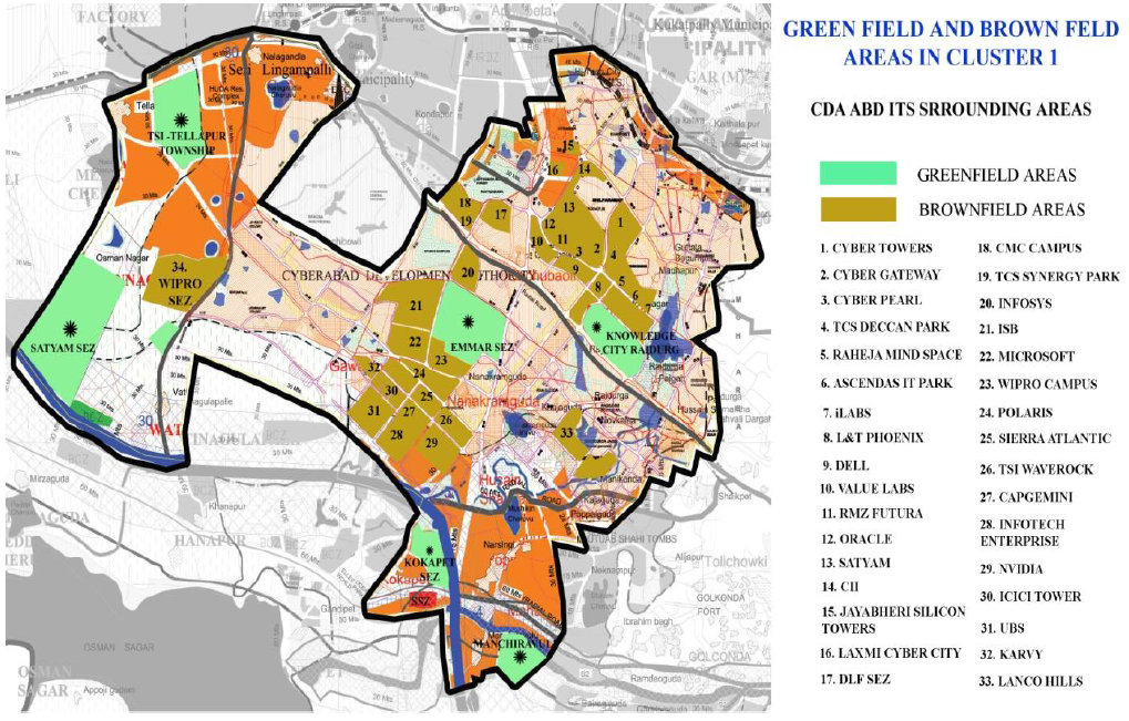
- A mix of brown-field and green-field development – inclusion of existing developments and vacant land with potential for growth in future
- Current agglomerations being connected through the growth corridor
- Master Plan of the proposed ITIR will be integrated with the HMDA Master Plan
- Integration with the existing and proposed settlements
- Integration with the natural features
- Zone I: Zone 1 is proposed in the north - western part of ITIR, centring on Hitech city. The total size of this Zone is 86.70 sq km
- Zone II: This is proposed in the southern part of ITIR including Hardware park, Fab city and APIIC Work centre. It covers parts of Maheshwaram mandal. The total size of this Zone is 79.22 sq km
- Zone III: Zone III is designated in the north - eastern part of the ITIR area covering parts of Pocharam and Uppal Municipality with an interconnecting corridor along National Highway 202. The total area of this Zone is 10.25 sq km
- Zone IV: Zone IV is located in the western part of ITIR interconnecting Zone I and Zone II area along the ORR. The total area of zone IV is 11.50 sq km
- Zone V: Zone V is located in the eastern part of ITIR interconnecting Zone II area and Zone III along the ORR. . The total area of Zone V is 14.32 sq km


No comments:
Post a Comment
PLEASE NOTE: Please exercise utmost caution while posting comments and please refrain for using any abusive words or making any personal comments. Thank you for helping in maintaining a friendly environment and for contributing any information helping others! Let us make this a better place to serve useful info to all!